
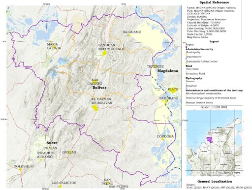
This article proposes the Territorial Sustainability Doughnut Model (TSDM), a multiscale interpretive framework that integrates land-use vocation, ecosystem-service trajectories, and field-based social evidence across vereda, municipal, and regional scales.
…
Montes de María provides a critical setting for this analysis because land-use change there is shaped by post-conflict governance fragmentation, hydroclimatic variability, and long-standing disputes over productive land and water. In recent years, these dynamics have been intensified by extreme variability associated with El Niño and La Niña, contributing to both flooding and prolonged droughts (Departamento Nacional de Planeación (DNP), 2020). Approximately 90% of the land in the study area is dedicated to agriculture, supported by the María La Baja swamp and an irrigation system that has historically influenced risk management and the organization of production (Alzate Mora, 2020). At the same time, conflicts over productive land have intensified, evolving from subsistence-based pressures toward agro-industrial expansion, particularly oil palm cultivation (Gonzalez, 2011). These conditions make Montes de María a suitable case for examining how land-use transitions interact with changes in ecosystem services and social vulnerability under territorially uneven governance.
Against this background, this article asks how a territorialized Doughnut framework, centered on land-use vocation and governance complexity, can be operationalized to connect multiscale land-use change, ecosystem-service trajectories, and field-based social conditions in a post-conflict rural landscape such as the Montes de María. To answer this question, the study combines multitemporal LULC analysis, land-use conflict diagnostics, and qualitative fieldwork across vereda, municipal, and regional scales. Its contribution lies in providing a place-based interpretive framework to assess whether observed land-use transitions are ecologically compatible, institutionally supported, and socially sustainable. Although the article focuses on a post-conflict rural case, the model is conceived as analytically transferable rather than mechanically replicable, since its value lies in adapting a common multiscale logic to context-specific interactions among land-use change, ecosystem-service pressures, and governance constraints.
…
The multiscale results indicate that territorial sustainability in Montes de María cannot be inferred solely from the intensity of land-use change. Transition maps show where dominant territorial trajectories concentrate, while white areas indicate the absence of detectable land-use change rather than missing information. Read alongside the vocation and zoning matrices, the key issue is not only how much land has changed, but whether those changes occurred under ecologically compatible, institutionally supported, or conflict-prone conditions.
Vereda-level results support this interpretation. The highest relative transformation was observed in Cascajo, El Carmen de Bolívar, where 16.51% of the area changed, mainly through reforestation-related transitions. Other high-change cases included Las Pelotas, with 9.94% transformed largely through temporary crop expansion, and Montecarlo, María La Baja, with 9.89% transformed mainly through permanent crop expansion. These trajectories were not spatially random: permanent crop expansion clustered mainly in María La Baja, temporary crop expansion was relevant in San Jacinto and El Guamo, and reforestation-related transitions were concentrated in selected veredas of El Carmen de Bolívar and Córdoba.
Because the indicators were derived from wall-to-wall mapped spatial units, the reported percentages describe mapped territorial intensity rather than inferential population estimates. Between 2010 and 2023, the most dynamic changes concentrated in María La Baja, Córdoba, and parts of El Carmen de Bolívar (Fig. 6). Change was markedly more intense during 2010–2016, when more than 70% of veredas registered detectable LULC transitions, whereas 2016–2023 showed greater persistence of previously established trajectories and conflictive transitions (Fig. 7; Supplementary Table A3 and Supplementary Table A4). Overall, regional dynamics combined productive expansion with localized vegetation recovery rather than following a single linear trajectory of degradation or improvement.
…
This article addresses the guiding question by showing how the TSDM can be operationalized as a territorialized, mixed-methods diagnostic that links multiscale LULC evidence, ecosystem-service trajectories, and field-based social conditions under governance complexity. Conceptually, the TSDM extends the interpretive logic of Doughnut Economics by translating Raworth’s dual thresholds, the social foundation and the ecological ceiling, into a place-based, spatially explicit framework in which land-use vocation mediates the balance between ecological integrity and social needs (Dragicevic, 2024; Ramirez and Lizarazo, 2025; Raworth, 2018; Ross, 2019). This addresses a persistent limitation in SDG-aligned indicator frameworks and EO-based monitoring: many indicator systems remain measurable and policy-relevant but struggle to represent territorial heterogeneity, cross-scale dynamics, governance fragmentation, and land-use conflicts (Dong and Hauschild, 2017; Eisenmenger et al., 2020; Usubiaga-Liaño and Ekins, 2021).
Now I want a doughnut…